Image
Flood Ready banner
Page Title
Flooding & Safety
Back to top

HEC-2 and HEC-RAS data library

Content

Here you can look at the HEC-2 and HEC-RAS files and download them for further study.

These files contain data for the HEC-2 and HEC-RAS hydraulic models developed by the US Army Corps of Engineers Hydrologic Engineering Center. The data were used to calculate water surface elevations in the creeks for previous flood insurance studies in Santa Clara County.

Note that these data files may be 20-25 years old and may not reflect the current creek condition. The District also maintains HEC-RAS and HEC-2 files that are generated in District's flood control projects. If you need those data, please contact Liang Xu at [email protected].

Disclaimer: The District is offering this information as a free service. We cannot guarantee the accuracy of your modeling results.

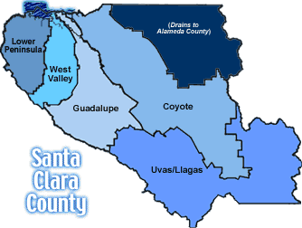
lower pen west valley guadalupe uvas coyote

ADOBE CREEK

HEC-2 Runs Available for ADOBE CREEK in the lowerPeninsula Watershed:
File Id Reach Location Type Description
1010007 127+50- 251+70 D/S 101-EL CAMINO Flood Insurance Study FROM FIS: MODIFIED WITH EDIT2: MODIFIED - 7/92 - SMW
1010008 202+72- 177+50 CHARLESTON-GROVE Flood Insurance Study SUPERCRITICAL: FROM FIS; MOD. TO CORRECT ERRORS PER EDIT2
1010009 338+61- 462+45 FOOTHILL - HWY 280 Flood Insurance Study FROM FIS, MODIFIED TO CORRECT ERRORS PER EDIT2
1010010 220+38- 258+69 CENTRAL-U/S EL CAM Flood Insurance Study FROM FIS; MODIFIED TO CORRECT ERRORS PER EDIT-2
 

ALAMITOS CREEK

HEC-2 Runs Available for ALAMITOS CREEK in the guadalupe Watershed:
File Id Reach Location Type Description
3010001 21+70- 175+00 LWR PP-CAMDEN BR Flood Insurance Study REVISED: 1977
3010002 22+34- 42+65 PERC PDS-MADRONE Flood Insurance Study '86 FLOW ANALYSIS
3010004 42+65- 187+40 MADRONE - CAMDEN Flood Insurance Study MODIFIED: EDIT2
3010005 175+00- 235+33 CALERO CON-MCKEAN Flood Insurance Study '86 FLOW ANALYSIS
3010014 22+38 42+25 Percolation Ponds (Almaden Lake)145ft U/S of Gulf Crk Confluence Flood Insurance Study prepared by WWL - Nolte & Associates 100-year run modified: see run text for modifications
3010015 42+25 54+03 145ft U/S of Gulf Crk Confluence 1323ft U/S of Gulf Crk Confluence Flood Insurance Study prepared by WWL - Nolte & Associates 100-year run Modified from SCVWD Alamitos ck run #6 by Nolte & Assoc (3/91)
3010016 42+25 54+03 145ft U/S of Gulf Crk Confluence 3997ft D/S of Greystone Crk Confluence Flood Insurance Study prepared by WWL - Nolte & Associates 100-year run Modified from SCVWD Alamitos ck run #6 by Nolte & Assoc (8/91)
3010017 42+25 62+00 145ft U/S of Gulf Crk Confluence 2120ft U/S of Gulf Crk Confluence Flood Insurance Study Prepared by DJS - Nolte & Associates 100 year run Modified from decks ALAM6BAS.HC2 and ALAMMAIN.HC2
3010018 42+25 62+00 145ft U/S of Gulf Crk Confluence 2120ft U/S of Gulf Crk Confluence Flood Insurance Study Prepared by DJS - Nolte & Associates 100 year run Modified from decks ALAM6BAS.HC2 and ALAMMAIN.HC2
3010019 42+29 62+00 149ft U/S of Gulf Crk Confluence 2120ft U/S of Gulf Crk Confluence Flood Insurance Study Prepared by DJS - Nolte & Associates 100 year run Modified from decks ALAM6BAS.HC2 and ALAMMAIN.HC2
3010020 42+29 80+28 149ft U/S of Gulf Crk Confluence 1372ft D/S of Greystone Crk Confluence Flood Insurance Study Prepared by DJS - Nolte & Associates 100 year run Modified from decks ALAM6BAS.HC2 and ALAMMAIN.HC2
3010021 54+03 93+65 145ft U/S of Gulf Crk Confluence 35ft D/S of Greystone Crk Confluence Flood Insurance Study Prepared by DJS - Nolte & Associates 100 year run Eastern levee modified from as built drawings
3010022 54+03 106+00 1323ft U/S of Gulf Crk Confluence 1120ft D/S of Greystone Ln Bridge Flood Insurance Study Prepared by DJS - Nolte & Associates 100 year run Eastern levee modified from as built drawings
3010023 54+03 187+40 1323ft U/S of Gulf Crk Confluence Camden Ave Bridge (D/S face) Flood Insurance Study Prepared by DJS - Nolte & Associates 100 year run Eastern levee modified from as built drawings
3010024 62+00 74+42 2120ft U/S of Gulf Crk Confluence 1958ft D/S of Greystone Crk Confluence Flood Insurance Study Prepared by DJS - Nolte & Associates 100 year run Modified from deck ALAM6BAS.HC2
3010025 62+00 76+59 2120ft U/S of Gulf Crk Confluence 1741ft D/S of Greystone Crk Confluence Flood Insurance Study Prepared by DJS - Nolte & Associates 100 year run Modified from deck ALAM6BAS.HC2
3010026 62+00 80+28 2120ft U/S of Gulf Crk Confluence 1372ft D/S of Greystone Crk Confluence Flood Insurance Study Prepared by DJS - Nolte & Associates 100 year run Modified from deck ALAM6BAS.HC2
3010027 93+65 116+73 35ft D/S of Greystone Crk Confluence 47ft D/S of Greystone Lane Bridge Flood Insurance Study Prepared by DJS - Nolte & Associates 100 year run
3010028 117+20 140+02 Greystone Lane Bridge (D/S face) Randol Crk confluence - 140+50 Flood Insurance Study Prepared by DJS - Nolte & Associates 100 year run
3010029 140+02 187+40 Randol Crk confluence Camden Ave Bridge (D/S face) Flood Insurance Study Prepared by DJS - Nolte & Associates 100 year run
3010030 185+90 222+75 150ft D/S of Camden Ave Bridge 882ft D/S of McKean/Harry Rd Bridge Flood Insurance Study deck prepared by DJS - Nolte & Associates modified: see run text for modifications
3010031 185+90 222+15 150ft D/S of Camden Ave Bridge 882ft D/S of McKean/Harry Rd Bridge Flood Insurance Study deck prepared by DJS - Nolte & Associates modified: see run text for modifications
3010032 185+90 235+33 150ft D/S of Camden Ave Bridge 436ft U/S of McKean/Harry Rd Bridge Flood Insurance Study deck prepared by DJS - Nolte & Associates modified: see run text for modifications
3010033 222+15 231+59 882ft D/S of McKean/Harry Rd Bridge 62ft U/S of McKean/Harry Rd Bridge Flood Insurance Study deck prepared by DJS - Nolte & Associates modified: see run text for modifications
 

BAR.CR.OVERFLOW

HEC-2 Runs Available for BAR.CR.OVERFLOW in the lowerPeninsula Watershed:
File Id Reach Location Type Description
1015001 0+00- 18+82 BAR. CR.-SED.BASIN Flood Insurance Study .
 

BARRON CREEK

HEC-2 Runs Available for BARRON CREEK in the lowerPeninsula Watershed:
File Id Reach Location Type Description
1012006 10+45- 103+14 U/S 101-EL CAMINO Flood Insurance Study FROM FIS, MODIFIED TO CORRECT ERRORS PER EDIT2
1012007 135+71- 148+65 LAGUNA-RINCON DR Flood Insurance Study FROM FIS, MODIFIED TO CORRECT ERROES PER EDIT2
 

BARRON DIVERSN

Sorry, no run data sets are available for this creek.


BERRYESSA CREEK

HEC-2 Runs Available for BERRYESSA CREEK in the coyote Watershed:
File Id Reach Location Type Description
4017002 0+95- 144+80 L. PENN-MLPTS BLVD Flood Insurance Study FROM FIS, MODIFIED EDIT2 - ERRORS FIXED 11/98 SMW
4017003 144+80- 233+75 MLPTS BLVD-MORRILL Flood Insurance Study FROM FIS, MODIFIED EDIT2. ERRORS FIXED 11/98 SMW
4017009 0+00 72+20 Confluence w/ lower Penitencia ~380ft D/S of Tularcitos crk confluence Flood Insurance Study Michael Cadei - George S Nolte & Assoc 100 yr Approximate end location
4017010 0+00 115+00 Confluence w/ lower Penitencia crk Confluence w/ Piedmont crk Flood Insurance Study Michael Cadei - 100 yr George S. Nolte & Associates
4017011 0+00 115+00 Confluence w/ lower Penitencia crk Confluence w/ Piedmont crk Flood Insurance Study Michael Cadei - 100 yr George S. Nolte & Associates
4017012 0+00 115+00 Confluence w/ lower Penitencia crk Confluence w/ Piedmont crk Flood Insurance Study Michael Cadei - 100 yr George S. Nolte & Associates
4017013 0+00 115+00 Confluence w/ lower Penitencia crk Confluence w/ Piedmont crk Flood Insurance Study Michael Cadei - 100 yr George S. Nolte & Associates
4017014 0+00 115+00 Confluence w/ lower Penitencia crk Confluence w/ Piedmont crk Flood Insurance Study Michael Cadei - 100 yr George S. Nolte & Associates
4017015 0+00 115+00 Confluence w/ lower Penitencia crk Confluence w/ Piedmont crk Flood Insurance Study Michael Cadei - 100 yr George S. Nolte & Associates
4017016 0+00 115+00 Confluence w/ lower Penitencia crk Confluence w/ Piedmont crk Flood Insurance Study Michael Cadei - 100 yr George S. Nolte & Associates
4017017 0+00 115+00 Confluence w/ lower Penitencia crk Confluence w/ Piedmont crk Flood Insurance Study Michael Cadei - 100 yr George S. Nolte & Associates
4017018 0+00 115+00 Confluence w/ lower Penitencia crk Confluence w/ Piedmont crk Flood Insurance Study Michael Cadei - 100 yr George S. Nolte & Associates
4017019 0+00 115+00 Confluence w/ lower Penitencia crk Confluence w/ Piedmont crk Flood Insurance Study Michael Cadei - 100 yr George S. Nolte & Associates
4017020 234+00 277+00 485ft U/S of Confluence w/ Sierra Crk 180ft D/S of Sweigert Crk Inlet Flood Insurance Study Approximate locations Michael Cadei - George S. Nolte & Associates
4017021 234+00 298+00 Confluence w/ Sierra Crk 75ft U/S of Old Piedmont Rd Crossing Flood Insurance Study Approximate end location Michael Cadei - George S. Nolte & Associates
4017022 234+00 298+00 Confluence w/ Sierra Crk 75ft U/S of Old Piedmont Rd Crossing Flood Insurance Study Approximate end location Michael Cadei - George S. Nolte & Associates
4017023 234+00 298+00 Confluence w/ Sierra Crk 75ft U/S of Old Piedmont Rd Crossing Flood Insurance Study Approximate end location Michael Cadei - George S. Nolte & Associates
4017024 234+00 298+00 Confluence w/ Sierra Crk 75ft U/S of Old Piedmont Rd Crossing Flood Insurance Study Approximate end location Michael Cadei - George S. Nolte & Associates
4017025 234+00 298+00 Confluence w/ Sierra Crk 75ft U/S of Old Piedmont Rd Crossing Flood Insurance Study Approximate end location Michael Cadei - George S. Nolte & Associates
4017026 234+00 298+00 Confluence w/ Sierra Crk 75ft U/S of Old Piedmont Rd Crossing Flood Insurance Study Approximate end location Michael Cadei - George S. Nolte & Associates
4017027 238+85 277+00 485ft U/S of Confluence w/ Sierra Crk Sweigert Crk Inlet Flood Insurance Study Approximate end location Michael Cadei - George S. Nolte & Associates
4017028 250+35 277+00 965ft D/S of Crosley Crk Drain inlet pt 180ft D/S of Sweigert Crk Inlet Flood Insurance Study Approximate locations Michael Cadei - George S. Nolte & Associates
4017029 258+15 277+00 185ft D/S of Crosley Crk Drain Inlet pt Sweigert Crk Inlet Flood Insurance Study Approx locations - run starts at (820) Michael Cadei - George S. Nolte & Associates
 

CALABAZAS CK

HEC-2 Runs Available for CALABAZAS CK in the west Valley Watershed:
File Id Reach Location Type Description
2010001 0+00- 102+14 GUAD.SLOUGH-D/S101 Flood Insurance Study FROM FIS, MODIFIED: EDIT2 & 1% & 10% FLOW ANALYSIS
2010002 102+30- 195+32 HWY101-CALBZS BL. Flood Insurance Study FROM FIS, MODIFIED: EDIT2 & 1% & 10% FLOW ANALYSIS
2010003 195+32- 338+03 CALBZS BL-PRNRIDGE Flood Insurance Study FROM FIS, MODIFIED: EDIT2
2010005 287+65- 88+04 U/S BENTON-D/S 101 Flood Insurance Study SUPERCRITICAL RUN - MODIFIED; EDIT2 - MODIFIED 7/92 - SMW
2010006 338+19- 500+62 PRNRIDGE-KRIESLER Flood Insurance Study FROM FIS, MODIFIED: EDIT2
2010007 518+62- 584+62 PROSPECT-WARDELL Flood Insurance Study FROM FIS, MODIFIED: EDIT2 & 1% & 10% FLOW ANALYSIS
 

CALERA CREEK

HEC-2 Runs Available for CALERA CREEK in the coyote Watershed:
File Id Reach Location Type Description
4018001 0+80- 8+73 U/S CONF.-U/S SPRR Flood Insurance Study FROM FIS, MODIFIED: EDIT2 - ET PROBLEMS REMAIN
4018002 36+70- 74+25 MLPTS HS-U/S 680 Flood Insurance Study FROM FIS, MODIFIED: EDIT2 - ET PROBLEMS REMAIN
4018003 74+25- 36+70 680-D/S ESCUELA Flood Insurance Study FROM FIS, SUPERCRITICAL - ET PROBLEMS REMIAN
4018008 0+00 21+00 Confluence w/ Berryessa 100ft D/S of Arizona Dr dbl RCB Flood Insurance Study Michael Cadei - 100 year - Approximate end location run Approximate end location
4018009 0+00 21+00 Confluence w/ Berryessa 100ft D/S of Arizona Dr dbl RCB Flood Insurance Study Michael Cadei - George S. Nolte & Assoc 100 year Approximate end location
4018010 0+00 31+60 Confluence w/ Berryessa 840ft D/S of Esquela Prkwy dbl Box Flood Insurance Study Michael Cadei - George S. Nolte & Assoc 100 year Approximate end location
4018011 0+00 36+30 Confluence w/ Berryessa 370ft D/S of Esquela Prkwy dbl Box Flood Insurance Study Michael Cadei - George S. Nolte & Assoc 100 year Approximate end location
4018012 0+00 74+25 Confluence w/ Berryessa 500ft U/S of Hwy 680 RCB Flood Insurance Study Michael Cadei - George S. Nolte & Assoc 100 year Approx. end location - old station 74+25
4018013 0+00 74+25 Confluence w/ Berryessa 500ft U/S of 680 hwy Flood Insurance Study Michael Cadei - George S. Nolte & Assoc 100 year Approx. end location - Old station 74+25
 

CALERO CREEK

HEC-2 Runs Available for CALERO CREEK in the guadalupe Watershed:
File Id Reach Location Type Description
3012001 0+00- 44+85 ALMTS CON.-HARY BR Flood Insurance Study FROM FIS, MODIFIED: EDIT2
 

CANOAS CREEK

HEC-2 Runs Available for CANOAS CREEK in the guadalupe Watershed:
File Id Reach Location Type Description
3011001 0+00- 105+74 C/GUAD. R.-CAPITOL Flood Insurance Study FIS, MODIFIED: EDIT2
3011002 105+74- 260+63 CAPITOL-SNTA TRESA Flood Insurance Study FIS, MODIFIED: EDIT2
3011003 260+63- 388+30 SNTA TRESA - LIMIT Flood Insurance Study FIS, MODIFIED: EDIT2
 

CORRALITOS

HEC-2 Runs Available for Corralitos in the uvas Llagas Watershed:
File Id Reach Location Type Description
5021001 50+00 150+00 E Middle Ave Bridge (DS face) End of jurisdiction Flood Insurance Study Prepared by DJS - Corralitos flood study. Nolte & Assoc. Approximate end location
5021002 50+00 150+00 E Middle Ave Bridge (DS face) End of jurisdiction Flood Insurance Study Prepared by DJS - Corralitos crk floodway-base flow Approximate end location
 

COYOTE CREEK

HEC-2 Runs Available for COYOTE CREEK in the coyote Watershed:
File Id Reach Location Type Description
4021002 455+00- 788+30 L.PENN-D/S BROKAW Flood Insurance Study FROM FIS, MODIFIED: EDIT2, EDITED - 6/92 - SMW
4021003 793+35- 936+00 BROKAW - U/S 101 Flood Insurance Study FROM FIS, MODIFIED: EDIT2, EDITED - 6/92 - SMW
4021004 936+00- 1057+00 U/S HWY 101-HWY280 Flood Insurance Study FROM FIS, MODIFIED: EDIT2, EDITED - 6/92 - SMW
4021005 1057+00- 1207+20 HWY 280 - TULLY RD1 Flood Insurance Study FROM FIS, MODIFIED: EDIT2, EDITED - 6/92 - SMW
4021006 1207+20- 1407+00 TULLY ROAD-HWY 1011 Flood Insurance Study FROM FIS, MODIFIED: EDIT2, EDITED - 6/92 - SMW
4021007 1407+00- 1716+25 101 - D/S C/FISHER1 Flood Insurance Study FROM FIS, MODIFIED: EDIT2, EDITED - 6/92 - SMW
4021008 1716+25- 1908+03 D/S C/FISH-R.G.C. 1 Flood Insurance Study FROM FIS, MODIFIED: EDIT2, EDITED - 6/92 - SMW
4021009 1908+03- 2203+70 R.C.G.-D/S ANDERSN1 Flood Insurance Study FROM FIS, MODIFIED: EDIT2, EDITED - 6/92 - SMW
4021018 SPRR 0+00 SPRR to BEGIN BYPAS Flood Insurance Study 1995 LOMR
4021019 0+00 51+50 BYPASS REACH 1A Flood Insurance Study 1995 LOMR
4021020 51+50 121+90 BYPASS REACH 1B Flood Insurance Study 1995 LOMR
4021021 500+00 571+00 REACH 2A Flood Insurance Study 1995 LOMR
4021022 571+00 595+00 REACH 2B D/S ALVI.BR Flood Insurance Study 1995 LOMR
4021023 596+50 628+00 REACH 3A BEGIN BYPASS Flood Insurance Study 1995 LOMR
4021024 628+00 727+00 BYPASS CHANNEL Flood Insurance Study 1995 LOMR
4021025 628+00 727+00 MAIN CHANNEL Flood Insurance Study 1995 LOMR
4021026 727+00 747+00 REACH 3E Flood Insurance Study 1995 LOMR
 

DEER CREEK

Sorry, no run data sets are available for this creek.

E. LITTLE LLAGAS

HEC-2 Runs Available for E. Little Llagas in the uvas Llagas Watershed:
File Id Reach Location Type Description
5037001 5+00 177+00 Church Crk Confluence Madrone Channel Confluence Flood Insurance Study djs - Nolte & Assoc - F/W 100-year profile
5037002 5+00 177+00 Church Crk Confluence Madrone Channel Confluence Flood Insurance Study srl - Nolte & Associates
5037003 97+00 170+00 San Martin Ave Middle Ave Flood Insurance Study cda - Nolte & Associates Approximate locations
5037004 177+00 194+00* Madrone Confl hwy101 RCB Llagas Rd (U/S face) Flood Insurance Study Approx locations - *west station located in West Little Llagas trw - Nolte & Assoc
 

EAST PENITENCIA

HEC-2 Runs Available for EAST PENITENCIA in the coyote Watershed:
File Id Reach Location Type Description
4049001 0+15- 35+50 L. PENIT. - LIMIT Flood Insurance Study FROM FIS, MODIFIED: EDIT2
 

EVERGREEN CREEK

Sorry, no run data sets are available for this creek.

FISHER CREEK

HEC-2 Runs Available for FISHER CREEK in the coyote Watershed:
File Id Reach Location Type Description
4023001 0+00- 184+69 C/COYOTE-U/S RCHMD Flood Insurance Study MODIFIED: EDIT2 - ET PROBLEMS IN RUN
4023002 0+00- 89+60 C/COYOTE-U/S RCHMD Flood Insurance Study FROM FIS, MODIFIED : EDIT2
4023003 1+42- 243+55 MONTRY HWY-SN BRNO Flood Insurance Study FROM FIS, MODIFIED : EDIT2
4023004 101+69- 180+68 BAILEY-U/S RCHMOND Flood Insurance Study FROM FIS, MODIFIED : EDIT2
4023005 180+50- 263+50 U/S RCHMD-SAN BRNO Flood Insurance Study FROM FIS, MODIFIED : EDIT2
4023006 231+00- 259+50 HALE-D/S SAN BRUNO Flood Insurance Study FROM FIS, MODIFIED : EDIT2
4023007 263+50- 384+55 SAN BRUNO - TILTON Flood Insurance Study FROM FIS, MODIFIED : EDIT2
4023008 0+00- 180+68 C/COYOTE-U/S RCHMD Flood Insurance Study FROM FIS - MODELS LEFT OVERBANK 100-YEAR FLOW (ALLEGED)
4023009 263+53- 310+53 SAN BRUNO-SANTATER Flood Insurance Study FROM FIS - RIGHT SIDE OF CHANNEL ISOLATED FLOW-(ALLEGED)
4023010 309+40- 314+30 SANTA TERESA - U/S Flood Insurance Study FROM FIS - ISOLATED FLOW ON LEFT SIDE OF CREEK-(ALLEGED)
 

GOLF CREEK

Sorry, no run data sets are available for this creek.

GREYSTONE CREEK

Sorry, no run data sets are available for this creek.

GUADALUPE CREEK

Sorry, no run data sets are available for this creek.

GUADALUPE RIVER

HEC-2 Runs Available for GUADALUPE RIVER in the guadalupe Watershed:
File Id Reach Location Type Description
3015006 0+00- 336+58 OVERBANK SWALE Flood Insurance Study RESTATIONING PROBLEM EXISTS - EDITED 10/94 - SMW
3015007 4+50- 516+50 BAY -AIRPORT PRKWY Flood Insurance Study FROM FIS, MODIFIED: EDIT2 - 10/94 - SMW
3015008 516+50- 707+10 AIRPORT PKWY - 280 Flood Insurance Study FROM FIS, MODIFIED: EDIT2, 10/94 - SMW
3015009 707+10- 874+77 280 -ALMADEN EXPWY Flood Insurance Study FROM FIS, MODIFIED:EDIT2, 10/94 - SMW
3015010 874+77- 1016+19 ALMDN EXPWY-BLSHIL Flood Insurance Study FROM FIS, MODIFIED: EDIT2 - 10/94 - SMW
 

GUADALUPE SLOUGH

Sorry, no run data sets are available for this creek.

HALE CREEK

HEC-2 Runs Available for HALE CREEK in the lowerPeninsula Watershed:
File Id Reach Location Type Description
1016002 0+00- 94+36 PERM/CONF-FOOTHILL Flood Insurance Study FROM FIS; MODIFIED TO CORRECT ERRORS PER EDIT2
 

L. PENITENCIA

HEC-2 Runs Available for L. PENITENCIA in the coyote Watershed:
File Id Reach Location Type Description
4033001 5+75- 121+10 U/S COYOTE-SERRA Flood Insurance Study FROM FIS, MODIFIED: EDIT2
4033002 97+77- 160+97 WELLER - CURTIS Flood Insurance Study FLOW ANALYSIS: R. SOTO, 1984
4033003 121+65- 201+50 SERRA AVE-E. PEN. Flood Insurance Study FROM FIS: MODIFIED EDIT2 - EDITED 10/92 - SMW
 

L. SILVER CREEK

HEC-2 Runs Available for L. SILVER CREEK in the coyote Watershed:
File Id Reach Location Type Description
4026001 50+00- 100+50 MCKEE-D/S SAN ANT. Flood Insurance Study FROM FIS, MODIFIED: EDIT2
4026002 100+50- 245+10 SAN ANT.-CUNGHM AV Flood Insurance Study FROM FIS, MODIFIED: EDIT2
4026003 245+10- 314+47 CUNGHM-THOMPSN CK Flood Insurance Study FROM FIS, MODIFIED: EDIT2
 

L. MILLER SLOUGH

HEC-2 Runs Available for L.MILLER SLOUGH in the uvas Llagas Watershed:
File Id Reach Location Type Description
5070003 0+00- 40+00 LLAGAS-PRINCEVALLE Flood Insurance Study FIS RUN ; CHANNEL GEOMETRY ESTIMATED WITH LIMITED DATA
 

LIONS CREEK

HEC-2 Runs Available for LIONS CREEK in the uvas Llagas Watershed:
File Id Reach Location Type Description
5039002 0+00- 104+54 W.B LLAGAS-END CON Flood Insurance Study LLAGAS WATERSHED PROJECT (PL566) ; CONDITIONAL LOMA 03/89
 

LLAGAS CREEK

HEC-2 Runs Available for LLAGAS CREEK in the uvas Llagas Watershed:
File Id Reach Location Type Description
5010001 0+59- 295+75 HWY 152-BUENA VSTA Flood Insurance Study FIS, WITH FIS STATIONING. MODIFIED: EDIT2
5010002 109+52- 422+65 GILROY DUMP-DENIO Flood Insurance Study FIS, MODIFIED: EDIT2
5010003 422+65- 695+10 DENIO - D/S SPRR Flood Insurance Study FIS, MODIFIED: EDIT2
5010004 695+10- 742+00 D/S SPRR-D/S OLIVE Flood Insurance Study FIS, MODIFIED: EDIT2
5010005 742+00- 1014+25 OLIVE-CHESBRO RES. Flood Insurance Study FIS, MODIFIED: EDIT2
5010011 64+00- 131+60 U/S BLOOMFIELD RD. Flood Insurance Study ADJACENT TO SEWAGE TREATMENT PLANT ; EFFLUENT CHANNEL
5010012 131+60- 182+90 MS - HWY 152 Flood Insurance Study CONDITIONAL LOMR REQUEST 5/18/89
5010013 182+90- 198+58 U/S HWY 152 Flood Insurance Study CONFLUENCE WITH WEST BRANCH LLAGAS CREEK
5010015 59+00- 295+75 LLAGAS OVERBANK Flood Insurance Study LLAGAS CREEK OVERBANK FROM FIA - MODIFIED 7/93 - SMW
 

LOS COCHES

HEC-2 Runs Available for Los Coches in the coyote Watershed:
File Id Reach Location Type Description
4025001 0+00 70+00 Confluence w/ Berryessa 200ft U/S of Old Piedmont Rd RCB Flood Insurance Study Michael Cadei - George S. Nolte & Associates 100 yr Approx locations
4025002 0+00 70+00 Confluence w/ Berryessa 200ft U/S of Old Piedmont Rd RCB Flood Insurance Study Michael Cadei - George S. Nolte & Associates 100 yr Approx locations
4025003 0+00 70+00 Confluence w/ Berryessa 200ft U/S of Old Piedmont Rd RCB Flood Insurance Study Michael Cadei - George S. Nolte & Associates 100 yr Approx locations
4025004 16+00 70+00 40ft U/S of Hwy 680 RCB 200ft U/S of Old Piedmont Rd RCB Flood Insurance Study Michael Cadei - George S. Nolte & Associates 100 yr Approx locations
4025005 16+00 70+00 40ft U/S of Hwy 680 RCB 200ft U/S of Old Piedmont Rd RCB Flood Insurance Study Michael Cadei - George S. Nolte & Associates 100 yr Approx locations
 

LOS GATOS CREEK

HEC-2 Runs Available for LOS GATOS CREEK in the guadalupe Watershed:
File Id Reach Location Type Description
3020002 2+48- 89+30 ST. PAUL - LINCOLN Flood Insurance Study FROM FIS, MODIFIED EDIT2, MODIFIED 3/93 SMW
3020005 287+00- 355+00 D/S SAN TOMAS-PERC Flood Insurance Study FROM FIS, MODIFIED EDIT2, MODIFIED 3/93 SMW
3020008 357+00- 445+00 PERC POND - VASONA Flood Insurance Study FROM FIS - MODIFIED EDIT2 - MODIFIED 3/93 SMW
3020013 348+88 418+01 D/S KIRK DAM-U/S LARK AVENUE Flood Insurance Study 2001 LOMR
 

MADRONE

HEC-2 Runs Available for Madrone in the uvas Llagas Watershed:
File Id Reach Location Type Description
5013001 0+00 220+00 Confluence w/ E Little Llagas Cochrane Rd (D/S) ~ US of 220+00 Flood Insurance Study cda - Nolte & Assoc - Hammon Jenson Wallen & Assoc 1988 - as built plans by Caltrans 1970
 

MATADERO CREEK

HEC-2 Runs Available for MATADERO CREEK in the lowerPeninsula Watershed:
File Id Reach Location Type Description
1021001 89+75- 199+08 HWY 101-EL CAMINO Flood Insurance Study FROM FIS, MODIFIED TO CORRECT ERRORS - SMW 10/93
1021002 198+78- 265+81 EL CAMINO-VET HOSP Flood Insurance Study FROM FIS, MODIFIED TO CORRECT ERRORS - SMW 10/93
 

N. MOREY CHANNE

Sorry, no run data sets are available for this creek.

NORWOOD CREEK

Sorry, no run data sets are available for this creek.

PERMANENTE CK

HEC-2 Runs Available for PERMANENTE CK in the lowerPeninsula Watershed:
File Id Reach Location Type Description
1024002 60+00- 126+93 BAY - HWY 101 Flood Insurance Study FROM FIS, MODIFIED: EDIT2 & RESTATIONED TO FACILITY STA.
1024003 228+40- 299+25 EL CAMINO-CUESTA Flood Insurance Study FROM FIS, MODIFIED: EDIT2 & RESTATIONED TO FACILITY STA.
1024004 423+04- 528+70 HWY 280-KAISER CEM Flood Insurance Study FROM FIS, MODIFIED: EDIT2 & RESTATIONED TO FACILITY STA.
1024018 51+60 90+21 S. boundary of Salt Evaporators ~ 60+00 (in Mountain View Slough) Amphitheatre Prkwy DS face ~ 103+09 Flood Insurance Study Nolte & Associates - 100 yr flood Case 1 created by Dan Schaaf
1024019 51+60 103+09 S. boundary of Salt Evaporators ~ 60+00 (in Mountain View Slough) Amphitheatre Prkwy D/S face ~ 103+09 Flood Insurance Study Nolte & Associates - 100 yr flood Case 2 - created by Dan Schaaf
1024020 51+60 111+81 S. boundary of Salt Evaporators ~ 60+00 (in Mountain View Slough) Charleston Rd D/S face - 20x10 RCB Flood Insurance Study Nolte & Associates - 100 yr flood Case 3 - created by Dan Schaaf
1024021 51+60 111+81 S. boundary of Salt Evaporators ~ 60+00 (in Mountain View Slough) Charleston Rd D/S face - 20x10 RCB Flood Insurance Study Nolte & Associates - 100 yr flood Case 4 - created by Dan Schaaf
1024022 51+60 129+12 S. boundary of Salt Evaporators ~ 60+00 (in Mountain View Slough) Hwy 101 U/S face - 12x11 box culvert Flood Insurance Study Nolte & Associates - 100 yr flood
1024023 51+60 129+12 S. boundary of Salt Evaporators ~ 60+00 (in Mountain View Slough) Hwy 101 U/S face - 12x11 box culvert Flood Insurance Study Nolte & Associates - 100 yr flood Case 6 - Created by Dan Schaaf
1024024 51+60 129+12 S. boundary of Salt Evaporators ~ 60+00 (in Mountain View Slough) Hwy 101 U/S face - 12x11 box culvert Flood Insurance Study Nolte & Associates - 100 yr flood Baylands created by Dan Schaaf
 

PERMANENTE DIV

Sorry, no run data sets are available for this creek.

PRINCEVALLE D.

Sorry, no run data sets are available for this creek.

ROSS CREEK

HEC-2 Runs Available for ROSS CREEK in the guadalupe Watershed:
File Id Reach Location Type Description
3023001 3+87- 122+98 ALMDEN EXPWY-CAMDN Flood Insurance Study FROM FIS: MODIFIED EDIT2, FURTHER MODIFIED SMW 3/93
 

S. BABB CREEK

HEC-2 Runs Available for S. BABB CREEK in the coyote Watershed:
File Id Reach Location Type Description
4013001 1+00- 75+20 CONF/SILVER-WLDMAN Flood Insurance Study FROM FIS, MODIFIED: EDIT2
4013002 75+20- 1+00 CONF/SILVER-CLAYTN Flood Insurance Study FROM FIS, SUPERCRITICAL MODIFIED: EDIT2
4013007 1+45 0+00 Farringdon Dr Box Culvert (D/S face) Confluence w/ Silver Crk Flood Insurance Study Nolte & Associates 100 yr run - supercritical
4013008 45+15 0+00 485ft D/S of Clayton Rd Confluence w/ Silver Crk Flood Insurance Study Approximate start location Nolte & Assoc-100yr run-supercritical
4013009 45+15 76+15 485ft D/S of Clayton Rd 2415ft U/S of Clayton Rd Flood Insurance Study Approximate locations Nolte & Assoc-100yr run-subcritical
 

S. MOREY CREEK

HEC-2 Runs Available for S. MOREY CREEK in the uvas Llagas Watershed:
File Id Reach Location Type Description
5053001 0+00- 35+97 WREN RD.-D/S MOREY Flood Insurance Study FIS, MODIFIED: EDIT2
 

SAN FRANCISQUITO

HEC-2 Runs Available for SAN FRANCISQUITO in the lowerPeninsula Watershed:
File Id Reach Location Type Description
1028001 75+30- 231+25 BAYSHORE-MIDDFIELD Flood Insurance Study FROM FIS-MODIFIED BY EDIT2 - MODIFIED - SMW - 2/93
1028002 222+30- 378+50 MIDDFIELD-FOOTHILL Flood Insurance Study FROM FIS - MODIFIED BY EDIT2 - MODIFIED - SMW - 2/93
 

SAN TOMAS CREEK

HEC-2 Runs Available for SAN TOMAS CREEK in the west Valley Watershed:
File Id Reach Location Type Description
2019008 147+61- 233+18 D/S 101-SAN TOM.EX Flood Insurance Study FROM FIS, MODIFIED: EDIT2
2019009 677+82- 770+75 QUITO - HWY 9 Flood Insurance Study FROM FIS; MODIFIED: SEE RUN TEXT FOR MODIFICATION
2019017 0+00 84+85 Confluence w/ Guadalupe Slough 985ft U/S of Tasman Dr. Bridge Flood Insurance Study Approximate end location Case A - prepared by DJS - Nolte & Assoc 100 yr run
2019018 0+00 84+85 Confluence w/ Guadalupe Slough 985ft U/S of Tasman Dr. Bridge Flood Insurance Study Approximate end location Case B - prepared by DJS - Nolte & Assoc 100 yr run
2019019 0+00 127+00 Confluence w/ Guadalupe Slough Agnew Rd. Bridge (D/S face) Flood Insurance Study Approximate end location Case C - prepared by DJS - Nolte & Assoc 100 yr run
2019020 0+00 127+00 Confluence w/ Guadalupe Slough Agnew Rd. Bridge (D/S face) Flood Insurance Study Approximate end location Case D - Prepared by DJS - Nolte & Assoc 100 yr run
2019021 0+00 133+00 Confluence w/ Guadalupe Slough Mission College Blvd Bridge (D/S face) Flood Insurance Study Approximate end location Case E - prepared by DJS - Nolte & Assoc 100 yr run
2019022 0+00 133+00 Confluence w/ Guadalupe Slough Mission College Blvd Bridge (D/S face) Flood Insurance Study Approximate end location Case F - prepared by DJS - Nolte & Assoc 100 yr run
2019023 0+00 153+00 Confluence w/ Guadalupe Slough Hwy 101 Bridge (D/S face) Flood Insurance Study Approximate end location Case G - prepared by DJS - Nolte & Assoc 100 yr run
2019024 0+00 153+00 Confluence w/ Guadalupe Slough Hwy 101 Bridge (D/S face) Flood Insurance Study Approximate end location Case H - prepared by DJS - Nolte & Assoc 100 yr run
2019025 0+00 168+00 Confluence w/ Guadalupe Slough Scott Blvd. Bridge (D/S face) Flood Insurance Study Approximate end location Case I - prepared by DJS - Nolte & Assoc 100 yr run
2019026 0+00 168+00 Confluence w/ Guadalupe Slough Scott Blvd. Bridge (D/S face Flood Insurance Study Approximate end location Case J - prepared by DJS - Nolte & Assoc 100 yr run
2019027 0+00 225+00 Confluence w/ Guadalupe Slough Confluence w/ Saratoga Crk Flood Insurance Study Nolte & Associates - 100 yr run Base deck - prepared by DJS
 

SARATOGA CREEK

HEC-2 Runs Available for SARATOGA CREEK in the west Valley Watershed:
File Id Reach Location Type Description
2021010 0+20- 170+25 SAN TOM-U/S PRNRDG Flood Insurance Study FIS, MODIFIED: EDIT2
2021011 147+40- 183+31 PRNRDG-STVNS CREEK Flood Insurance Study FIS RUN ; MODIFIED EDIT2 ; RESTATIONED TO SCVWD STA 1/89
2021012 369+44- 530+70 SPRR-AMBRIC KNOLLS Flood Insurance Study FIS DATA
 

SIERRA CREEK

HEC-2 Runs Available for SIERRA CREEK in the coyote Watershed:
File Id Reach Location Type Description
4037001 0+00- 72+22 C/BRYESA-MANUA KEA Flood Insurance Study FROM FIS, MODIFIED: EDIT2
4037002 133+10- 112+75 LIMIT - ONSLOW Flood Insurance Study FROM FIS, SUPERCRITICAL FLOW, MODIFIED: EDIT2
 

SMITH CREEK

HEC-2 Runs Available for SMITH CREEK in the west Valley Watershed:
File Id Reach Location Type Description
2023001 56+86- 104+14 SPRR - BICKNELL Flood Insurance Study FROM FIS; 1970s
 

STEVENS CREEK

HEC-2 Runs Available for STEVENS CREEK in the lowerPeninsula Watershed:
File Id Reach Location Type Description
1029006 50+00- 220+78 BAY - DANA Flood Insurance Study MODIFIED:EDIT2 & RESTATIONED TO DISTRICT STA. - 6/99 SMW
1029007 434+00- 629+10 HOMESTEAD-D/S RES. Flood Insurance Study FROM FIS, MODIFIED: EDIT2 & RESTATIONED TO FACILITY STA.
1029008 627+10- 665+10 D/S RES. - RES. Flood Insurance Study FROM FIS, MODIFIED: EDIT2 & RESTATIONED TO FACILITY STA.
 

SUNNYVALE EAST

HEC-2 Runs Available for SUNNYVALE EAST in the west Valley Watershed:
File Id Reach Location Type Description
2026003 4+00- 186+47 GUAD.SL.-S.PAC.RR. Flood Insurance Study FIS RUN 3/88
2026004 186+47- 311+59 SPRR - DUNHOLME Flood Insurance Study FIS RUN 1970s
2026010 0+00 35+00 Guadalupe Slough Confluence Caribbean Dr Bridge (D/S face) Flood Insurance Study Approximate end location Case A - created by DJS - Nolte & Assoc
2026011 0+00 60+00 Guadalupe Slough Confluence Hwy 237 RCB (DS face) Flood Insurance Study Approximate end location Case B - prepared by DJS - Nolte & Assoc
2026012 0+00 60+00 Guadalupe Slough Confluence Hwy 237 RCB (DS face) Flood Insurance Study Approximate end location Case C - prepared by DJS - Nolte & Assoc
2026013 0+00 81+00 Guadalupe Slough Confluence Tasman Dr RCB (DS face) Flood Insurance Study Approximate end location Case D - prepared by DJS - Nolte & Assoc
2026014 0+00 81+00 Guadalupe Slough Confluence Tasman Dr RCB (DS face) Flood Insurance Study Approximate end location Case E - prepared by DJS - Nolte & Assoc
2026015 0+00 109+00 Guadalupe Slough Confluence Hwy 101 RCB (DS end) Flood Insurance Study Approximate end location Case F - prepared by DJS - Nolte & Assoc
2026016 0+00 109+00 Guadalupe Slough Confluence Hwy 101 RCB (DS end) Flood Insurance Study Approximate end location Case G - prepared by DJS - Nolte & Assoc
2026017 0+00 112+00 Guadalupe Slough Confluence 670ft U/S of Hwy 101 RCB Flood Insurance Study Approximate end location Base - prepared by DJS - Nolte & Assoc
 

SUNNYVALE WEST

HEC-2 Runs Available for SUNNYVALE WEST in the west Valley Watershed:
File Id Reach Location Type Description
2027002 4+00- 143+00 GUAD. SL.- HWY 101 Flood Insurance Study FIA RUN - 1970s
2027007 39+00 75+00 Bayfront Levee(3600ft DS of Java Dr) Java Dr RCB (DS face) Flood Insurance Study Approximate locations (stations) Case A - prepared by DJS - Nolte & Assoc 100 yr run
2027008 39+00 75+00 Bayfront Levee(3600ft DS of Java Dr) Java Dr RCB (DS face) Flood Insurance Study Approximate locations (stations) Case B - prepared by DJS Nolte & Assoc 100 yr run
2027009 39+00 94+00 Bayfront Levee(3600ft DS of Java Dr) Bordeaux Dr (DS face) Flood Insurance Study Approximate locations (stations) Case C - prepared by DJS Nolte & Assoc 100 yr run
2027010 39+00 94+00 Bayfront Levee(3600ft DS of Java Dr) Bordeaux Dr (DS face) Flood Insurance Study Approximate locations (stations) Case D - prepared by DJS - Nolte & Assoc 100 yr run
2027011 39+00 123+60 Bayfront Levee(3600ft DS of Java Dr) 1960ft U/S of Mathilda Ave Flood Insurance Study Approximate locations (stations) Base - prepared by DJS - Nolte & Assoc 100 yr run
2027012 39+00 123+60 Bayfront Levee(3600ft DS of Java Dr) 1960ft U/S of Mathilda Ave Flood Insurance Study Approximate locations (stations) Nolte & Associates
 

TENNANT CREEK

Sorry, no run data sets are available for this creek.

THOMPSON CREEK

HEC-2 Runs Available for THOMPSON CREEK in the coyote Watershed:
File Id Reach Location Type Description
4047001 2+71- 89+95 C/SLVR-CADWALLADER Flood Insurance Study EXTRACTED FROM FIS SILVER CREEK, MODIFIED: EDIT2
4047002 10+30- 70+60 QUIMBY RD-ABORN RD Flood Insurance Study FLOW ANALYSIS: J. ROYBAL 1977: MODIFIED: EDIT2
4047003 70+41- 195+26 ABORN-C/YERBABUENA Flood Insurance Study FROM FIS, MODIFIED: EDIT2
 

U. PENITENCIA

HEC-2 Runs Available for U. PENITENCIA in the coyote Watershed:
File Id Reach Location Type Description
    COYOTE-U/S JACKSON Flood Insurance Study FROM FIS, REVISED J. MICKO, '82; MODIFIED: EDIT2
4032002 1+25- 187+10 COYOTE - ALBA CT. Flood Insurance Study FROM FIS, MODIFIED: EDIT2, SMW
4032003 20+38- 94+00 SPRR - U/S JACKSON Flood Insurance Study FROM FIS, MODIFIED: EDIT2
4032004 191+00- 201+10 U/S ALBA CT-NOBLE Flood Insurance Study FROM FIS, MODIFIED: EDIT2
4032013 160+50- 173+10 PRV BRGIDG-PIEDMON Flood Insurance Study MODIFIED FIS RUN - RATING FOR STREAMGAGE
 

U. MILLER SLOUGH

HEC-2 Runs Available for U.MILLER SLOUGH in the uvas Llagas Watershed:
File Id Reach Location Type Description
5071002 0+00- 109+70 C/W.B.LL - WAYLAND Flood Insurance Study FIS RUN - MODIFIED WITH EDIT2 - POST PL566 FLOWS USED
5071003 0+00- 109+70 C/W.B.LL.-WAYLAND Flood Insurance Study OLD FIS RUN ; MODIFIED BY EDIT 2 ; PRE PL566 FLOWS
5071004 0+00- 33+90 WAYLAND - LIONS - Flood Insurance Study OLD FIS RUN ; *** FAULTY STATIONING *** ; PRE PL566 FLOWS
 

UPPER SILVER

HEC-2 Runs Available for Upper Silver in the coyote Watershed:
File Id Reach Location Type Description
4038001 0+00 60+00 Confluence w/ Coyote crk End conc trap channel Flood Insurance Study Approx start location Nolte & Associates
4038002 60+00 End conc trap channel Hole No. 2-Golf Cart Bridge (US face) ~ (452)? -180+00-250+00? Flood Insurance Study End location unknown Nolte & Associates
4038003 74+00 100+30 ~107ft U/S of Silver Crk Rd (D/S crossing) 1030ft U/S of Silver Crk Rd Flood Insurance Study Approximate locations Nolte & Associates
 

UVAS CARNADERO

HEC-2 Runs Available for UVAS-CARNADERO in the uvas Llagas Watershed:
File Id Reach Location Type Description
5018001 209+00- 579+70 SPRR - HECKER PASS Flood Insurance Study FIS, MODIFIED: EDIT2 & 266' ADDED - MODIFIED SMW 1/93
5018016 154+00 189+00 Hwy 25 (Hollister Rd) undercrossing 1750-1800ft U/S of Bloomfield Ave Flood Insurance Study Approximate locations 100 yr discharge - djs - Nolte & Assoc
5018017 193+90 210+00 ~1610ft D/S of SPRR Bridge SPRR Bridge Flood Insurance Study approximate stations (locations) 100 yr discharge - cda - Nolte & Assoc
5018018 193+90 360+00 ~1610ft D/S of SPRR Bridge 1750-2300ft D/S of Thomas Rd Br Flood Insurance Study Approximate locations 100 yr discharge - djs - Nolte & Assoc
5018019 193+90 360+00 ~1610ft D/S of SPRR Bridge 1750-2300ft D/S of Thomas Rd Br Flood Insurance Study Approximate locations 100 yr discharge - djs - Nolte & Assoc
5018020 193+90 360+00 ~1610ft D/S of SPRR Bridge 1750-2300ft D/S of Thomas Rd Br Flood Insurance Study Approximate locations 100 yr discharge - djs - Nolte & Assoc
5018021 193+90 380+00 ~1610ft D/S of SPRR Bridge Thomas Rd Bridge (U/S face) Flood Insurance Study Approximate locations 100 yr discharge - djs - Nolte & Assoc
5018022 210+00 211+00 SPRR Bridge SPRR Bridge Flood Insurance Study Stage-discharge: flow over lower SPRR 100 yr discharge - cda - Nolte & Assoc
5018023 210+00 265+00 SPRR Bridge hwy 101 (Monterey) Flood Insurance Study Approximate locations 100 yr discharge - cda - Nolte & Assoc
5018024 210+00 265+00 SPRR Bridge hwy 101 (Monterey) Flood Insurance Study Approximate Locations 100 yr discharge - djs - Nolte & Assoc
5018025 225+50 360+00 ~1550ft U/S of SPRR Bridge 1750-2300ft D/S of Thomas Rd Br Flood Insurance Study Approximate locations 100 yr discharge - djs - Nolte & Assoc
5018026 265+00 268+00 hwy 101 (Monterey) - D/S face hwy 101 (Monterey) - U/S face Flood Insurance Study Approximate locations - ROB at 101 Weir/culvert balance - case 4
5018027 265+00 268+00 hwy 101 (Monterey) - D/S face hwy 101 (Monterey) - U/S face Flood Insurance Study Approximate locations - ROB at 101 Weir/culvert balance - case 5
5018028 265+00 268+00 hwy 101 (Monterey) - D/S face hwy 101 (Monterey) - U/S face Flood Insurance Study Stage discharge: flow over 101 100 yr discharge - cda - Nolte & Assoc
5018029 265+00 268+00 hwy 101 (Monterey) - D/S face hwy 101 (Monterey) - U/S face Flood Insurance Study Stage discharge: return flow to crk 100 yr discharge - cda - Nolte & Assoc
5018030 265+00 268+00 hwy 101 (Monterey) - D/S face hwy 101 (Monterey) - U/S face Flood Insurance Study Stage discharge: flow back to lower crk 100 yr discharge - cda - Nolte & Assoc
5018031 265+00 268+00 hwy 101 (Monterey) - D/S face hwy 101 (Monterey) - U/S face Flood Insurance Study Stage discharge: flow over Monterey Hwy 100 yr discharge - cda - Nolte & Assoc
5018032 268+00 293+60 U/S Highway 101 2560ft U/S of hwy 101 Flood Insurance Study approximate stations (locations) 100 yr discharge - djs - Nolte & Assoc
5018033 268+00 293+60 U/S Highway 101 2560ft U/S of hwy 101 Flood Insurance Study approximate stations (locations)100 yr discharge - djs - Nolte & Assoc
5018035 251+00 265+00 ~1400ft D/S of hwy 101 (Monterey) Flood Insurance Study stage disch:flow past sprr-over monterey hwy 100 yr discharge - cda - Nolte & Assoc
5018036 574+30 900+00 ~470ft D/S of Hecker Pass/hwy 152 Br 100-200ft D/S of Solis Crk confluence Flood Insurance Study Approximate locations 100-year flow - cda/trw - Nolte & Associates
5018037 574+30 900+00 ~470ft D/S of Hecker Pass/hwy 152 Br 100-200ft D/S of Solis Crk confluence Flood Insurance Study Approximate locations Base flood (100 yr) - cda/trw - Nolte & Assoc
5018038 574+30 900+00 ~470ft D/S of Hecker Pass/hwy 152 Br 100-200ft D/S of Solis Crk confluence Flood Insurance Study Approximate locations Base flood (100 yr) - djs - Nolte & Associates
 

W. BRANCH LLAGAS

HEC-2 Runs Available for W.BRANCH LLAGAS in the uvas Llagas Watershed:
File Id Reach Location Type Description
5031011 4+00- 57+00 LLAGAS-D/S FWY 101 Flood Insurance Study 4/89 LOMA SUBMISSION ; POST PROJECT PL566 RUN
5031012 57+00- 168+89 D/S 101-U MONTEREY Flood Insurance Study 4/89 LOMA SUBMISSION ; POST PROJECT PL566 RUN
5031013 168+89- 218+78 U/S MONTEREY-U DAY Flood Insurance Study 4/89 LOMA SUBMISSION ; POST PROJECT PL566 RUN
5031021 1+85- 147+85 D/S SPRR-FIZGEROLD Flood Insurance Study FIS STATIONING ; PRE PROJECT PL566 RUN ; MODIFIED EDIT2
5031022 0+60- 147+85 N.SIDE PARK-GG AVE Flood Insurance Study FIS STATIONING ; PRE PROJECT PL566 RUN ; MODIFIED EDIT2
5031023 28+80- 292+70 TATUM-U/S HIGHLAND Flood Insurance Study FIS STATIONING ; PRE PROJECT PL566 RUN ; MODIFIED EDIT2
5031029 220+00 256+90 Day Rd Interceptor 3690ft U/S of Day Rd Interceptor Flood Insurance Study Approximate locations 100yr discharge - djs - Nolte & Associates
5031030 220+00 260+00 Day Rd Interceptor 4000ft U/S of Day Rd Interceptor Flood Insurance Study Approx start location - end station unknown 100yr discharge - djs - Nolte & Associates
5031031 220+00 260+00 Day Rd Interceptor 4000ft U/S of Day Rd Interceptor Flood Insurance Study Approximate locations 100yr discharge - djs - Nolte & Associates
5031032 220+00 400+00 Day Rd Interceptor highland Ave (D/S face) Flood Insurance Study Approximate locations 100yr floodway - djs - Nolte & Associates
5031033 220+00 400+00 Day Rd Interceptor highland Ave (D/S face) Flood Insurance Study Approximate locations 100yr floodway - djs - Nolte & Associates
5031034 220+00 400+00 Day Rd Interceptor highland Ave (D/S face) Flood Insurance Study Approximate locations 100yr discharge - djs - Nolte & Associates
5031035 220+00 400+00 Day Rd Interceptor highland Ave (D/S face) Flood Insurance Study Approximate locations 100yr discharge - djs - Nolte & Associates
5031036 220+00 400+00 Day Rd Interceptor highland Ave (D/S face) Flood Insurance Study Approximate locations 100yr discharge - djs - Nolte & Associates
5031037 220+00 420+00 Day Rd Interceptor 980ft U/S of Coolidge Ave Flood Insurance Study Approximate locations 100yr discharge - djs - Nolte & Associates
5031038 393+00 400+00 ~700ft D/S of Highland Ave highland Ave (D/S face) Flood Insurance Study Approx end location - start station unknown 100yr discharge - djs - Nolte & Associates
5031039 400+00 436+00 highland Ave (U/S) 2500ft U/S of Coolidge Ave Flood Insurance Study Approximate locations 100yr discharge - cda - Nolte & Associates
 

W. LITTLE LLAGAS

HEC-2 Runs Available for W.LITTLE LLAGAS in the uvas Llagas Watershed:
File Id Reach Location Type Description
5012001 0+06- 50+00 MIDDLE - U/S SPRR Flood Insurance Study FIS, MODIFIED: EDIT2
5012002 50+00- 212+30 U/S SPRR - LLAGAS Flood Insurance Study FIS, MODIFIED: EDIT2
5012003 213+65- 237+50 LLAGAS AVE - LIMIT Flood Insurance Study FIS, MODIFIED; EDIT2
5012010 35+00 102+00 From Watsonville Rd 6700ft U/S of Watsonville Rd Flood Insurance Study Approximate locations trw - Nolte & Associates
5012011 35+00 102+00 From Watsonville Rd 6700ft U/S of Watsonville Rd Flood Insurance Study Approximate locations djs - Nolte & Associates
5012012 167+00 190+00 Along Hale Ave-between Wright & W Main Ave 1500ft U/S of Hale/Wright intersection Flood Insurance Study Approx start location - end station unknown djs - Nolte & Associates
5012013 177+00* 224+00 Madrone Confl hwy101 RCB - East Little Llagas 1800ft u/s of Llagas Rd Flood Insurance Study *East Station - located in East little Lagas trw - Nolte & Associates
 

WILDCAT CREEK

HEC-2 Runs Available for WILDCAT CREEK in the west Valley Watershed:
File Id Reach Location Type Description
2030001 52+25- 157+52 D/S PORTOS-SAR-LG Flood Insurance Study FROM FIS; 1970s
 

WRIGLEY FORD CK

HEC-2 Runs Available for WRIGLEY-FORD CK in the coyote Watershed:
File Id Reach Location Type Description
4015001 1+55- 32+00 U/S BERYSA - LIMIT Flood Insurance Study ORIGIN OF THIS FLOW ANALYSIS IS NOT KNOWN